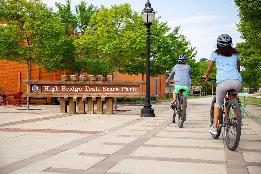
Virginia’s High Bridge Trail State Park
Trail of the Month: June 2024
In the last few decades, the tiny hamlet of Pamplin, Virginia, had earned a bit of a reputation. Once a thriving railroad hub and home to the largest manufacturer of clay pipes in the United States, the town of 200 had fallen on hard times, its hollowed out downtown only supporting 10 buildings. During the early 2000s, the community became synonymous with the words often used to describe it: endangered, abandoned, a ghost town.
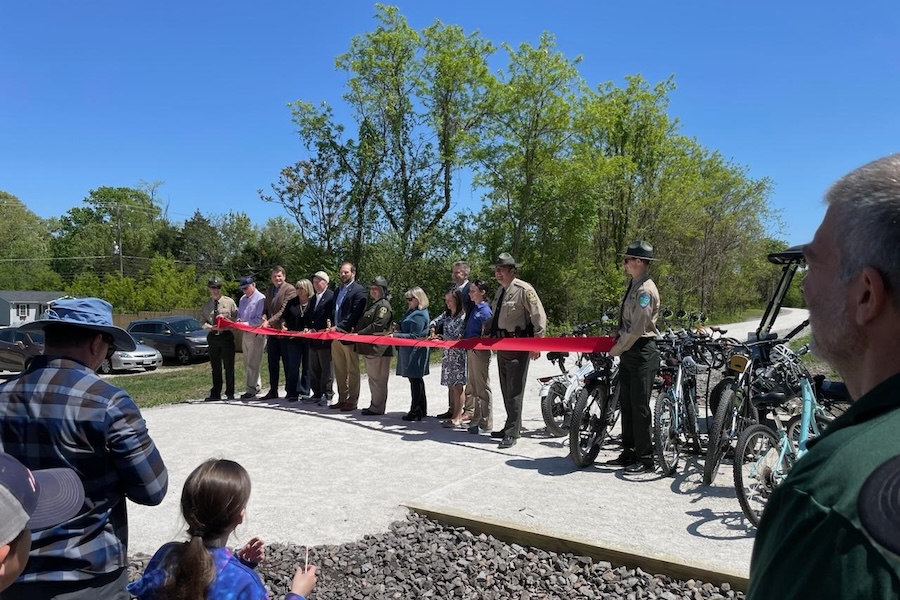
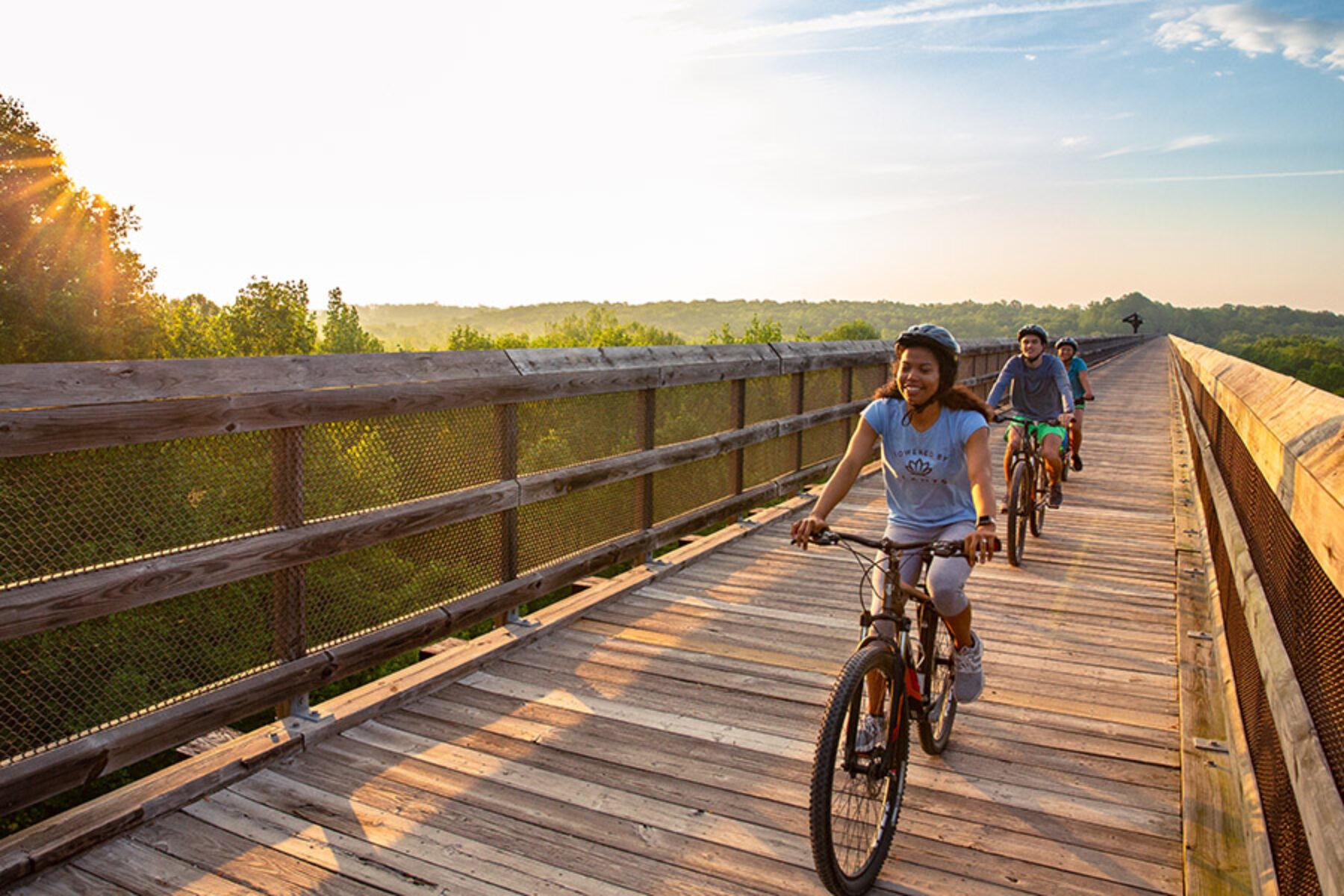
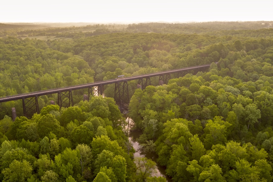
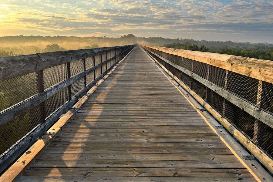
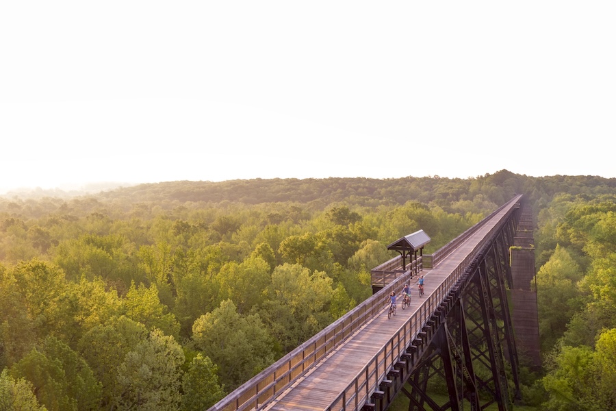
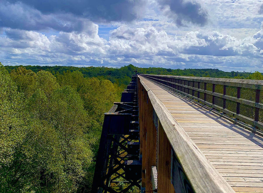
But as of this year, Pamplin has a new identity: trail town. On Earth Day, April 22, 2024, more than 100 people gathered for a triumphant ribbon cutting on a 1-mile extension of the now 32-mile High Bridge Trail State Park, which had stopped just short of the town when it was originally completed in 2012. As visitors flocked from around the region to enjoy the trail—and its majestic centerpiece, the 2,400-foot-long High Bridge, standing 125 feet over the Appomattox River—residents of Pamplin began campaigning for that extra mile.
It took 12 years, but today, a crushed gravel path deposits visitors onto a Main Street that’s showing new signs of life. Since word got out in 2020 that the trail was finally coming to Pamplin, said Regina Schwabe, the president of Friends of High Bridge Trail State Park, “there has been new investment in the town, and lots of interest in people buying up homes and businesses here. There’s a real revitalization going on.”
Pamplin may be the latest community to benefit from the trail, but it’s hardly the first.
For local residents, the trail represented not just a new asset, but a new attitude. “Everywhere you went, you really saw this pride of place happening.”
—Regina Schwabe, the president of Friends of High Bridge Trail State Park
Luring the Railroad to Town
In the early 1850s, the Southside Railroad began planning a rail line to connect the coastal ports of Virginia with agricultural communities in the central part of the state, what should have been a fairly straight path. But the finished railroad took a distinctly meandering route from ocean to farmland.
“The reason is that the residents of Farmville petitioned the Southside Railroad to change the route,” explained Daniel Jordan, the manager of High Bridge Trail State Park, which is headquartered in the town of Farmville. “They had been relying on boats and carriages to move goods, and they knew that the railroad would be a game changer for commerce.”
According to Jordan, the railroad agreed—for a price. “They said ‘we’ll move it if you pledge $100,000.’ That was $3.5 million back then. Best we can tell, though, only about $12,000 was ever given to the railroad. But Farmville was successful.”
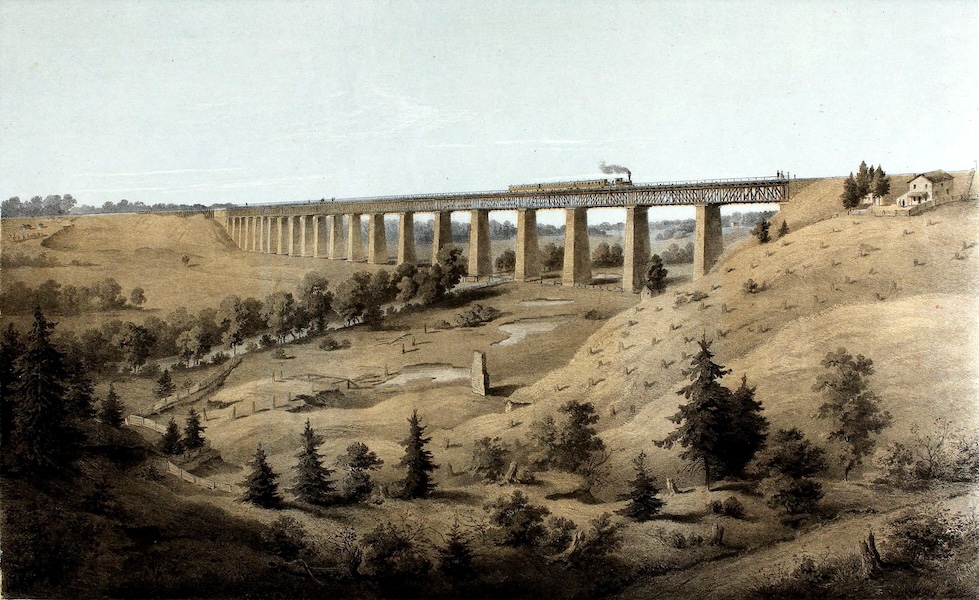
The route required a long (and expensive) crossing of the Appomattox River valley about 3 miles east of Farmville. When the bridge opened in 1854, it was an engineering marvel, built atop 20 piers containing almost 4 million bricks. There was a pedestrian walkway beside the tracks, and a lower bridge for wagons below them. The project’s chief engineer, C.O. Sanford, remarked that “there have been higher bridges not so long, and longer bridges not so high, but taking the length and height together, this is, perhaps the largest bridge in the world.”
During the run up to the Civil War, four forts were built to protect High Bridge, including one nicknamed Camp Paradise by the soldiers stationed there, who enjoyed homemade meals and performances put on by local residents.
“They didn’t think fighting would come near them,” said Jordan. “Nothing was supposed to happen in the south side of Virginia.”
The Battle of High Bridge
In the spring of 1865, General Robert E. Lee and his troops were in retreat after a bruising Union attack at Sailor’s Creek. After crossing High Bridge, the Confederate Army received orders to burn it, a strategy that would create a barrier between them and pursuing Union forces.
At 7 a.m. on April 7, Confederate troops ignited a pile of combustible material on the west side of the bridge. Coated with pitch tar as a preservative, the structure quickly went up in flames. The wagon bridge below the railroad, however, wasn’t as flammable; high river levels had recently soaked the wood.
Soon, the Union troops arrived and “started throwing railroad ties overboard to prevent the bridge from burning more,“ said Jordan. More consequentially, they were also able to capture the lower wagon bridge, securing a passage across the river.
Failure to destroy the bridge allowed the Union Army to catch up with Lee at Appomattox, where he ultimately surrendered. “The Battle of High Bridge was pretty significant to the end of the Civil War,” Jordan said. But in its aftermath, the bridge was in dire need of repair.
Boom, Bust, and Boom Again
After the war, the bridge was rebuilt while the railroad itself changed hands many times over, from the Southside Railroad to the Atlantic, Mississippi and Ohio Railroad to Norfolk Western and, finally, to Norfolk Southern. For a while, business was booming. So much so that the old wooden bridge needed to be rebuilt again.
“Throughout the 1800s, trains got longer and heavier,” said Jordan. “And by the 1900s, the railroad needed a new bridge.” In 1914, a new-and-improved steel High Bridge opened, but just two years later, he said, “the demise of High Bridge began.”
Construction on a new rail line south of Farmville was completed in 1916 and most traffic was diverted there. Soon, the only train cars crossing High Bridge were full of coal dust. In the following decades, the region’s other industries, textiles and tobacco among them, began their long, slow decline.
“These towns were basically abandoned,” said Schwabe of the communities along the modern-day rail-trail. “They were basically just intersections with run-down buildings.”
By the early 2000s, according to Jordan, Norfolk Southern “was tired of maintaining the bridge.” In 2006, the company donated 31.2 miles of track to the Virginia Department of Conservation and Recreation, and the agency spent six years converting the land into High Bridge Trail State Park. In April 2012, 147 years after the Union Army saved it from burning down, the restored bridge was reopened to walkers, bicyclists and horseback riders.
“Almost immediately, people were out jogging, photographing, pushing strollers, walking the dog,” said Schwabe. For local residents, the trail represented not just a new asset, but a new attitude. “Everywhere you went, you really saw this pride of place happening.”
Small Town Success
“Initially people who lived along the trail were very hesitant about the whole thing,” said Ann Ligon, who’s been a member of the Friends of High Bridge State Park since the land was donated to the state. “Suddenly they’d have the whole world hiking, biking and walking right by their house. But pretty soon, they realized their property was more valuable after the trail opened. Now people want to live near the trail.”
Ligon and her husband Woody still live in the home he grew up in on a hill overlooking the bridge. “When I was a child, we used to see steam trains passing across High Bridge. In the winter they produced so much steam that they left a trail of smoke all the way across the bridge,” he said. Today, the Ligons admire the bridge as it fills up with people during the events the park puts on, like June’s annual firefly festival as well as monthly foot and bike races.
Mark Smith, who owns Sandy River Outdoor Adventure Store, a bike rental and repair shop in downtown Farmville, said visitors come “from every corner of Virginia,” to enjoy the trail. Once they’ve changed out of their bike shorts or running shoes, visitors venture into towns like Rice—where Smith owns an adventure park—and Farmville.
“It’s the perfect getaway,” he said. “Lots of charm and good restaurants, but also affordable and safe.”
Trail-goers can also enjoy learning about Civil War history at nearby forts and battlefields, as well as the Civil Rights Movement. The Robert Russa Moton Museum in Farmville is a former high school where a 1951 student protest led to the infamous Brown v. Board of Education decision that found “separate but equal” policies were unconstitutional.
For Jordan, it’s gratifying to think that an effort by local residents more than 150 years ago to bring the railroad through the area is still bearing fruit. “This rail line was put in to connect the community for goods and commerce, and now it’s been repurposed to connect the communities once again.”
Constantly Evolving
For visitors looking to spend a few days in the area, Jordan noted there are five state parks within a 30 minute drive of Farmville—known locally as the “Farmville Five.” A few of them also offer camping.
According to Jordan, there’s no bad time to hit the trail, though the mild weather of spring and fall are particularly ideal. “High summer is usually our slow time,” he said, “we’re not your typical park in that way.”
Atypical is right, according to Schwabe. “Unlike so many state parks that can be a little cookie-cutter, at High Bridge something new comes up all the time—a new event, a new parcel of land to explore, a new section of the trail. It’s constantly evolving as the needs of area are being met.”
Back in Pamplin, Schwabe said she’s still a bit “thunderstruck” to see the trailhead in town, after more than a decade of campaigning for it.
“We wrote to three different governors and countless delegates. We had meetings with the park and the railroad. We got the money and built a parking lot for the trail,” she said. “That’s how much we wanted it.”
Related Links
Trail Facts
Name: High Bridge Trail State Park
Used railroad corridor: This rail line changed hands many times. Built by the Southside Railroad Company prior to the Civil War, the tracks belonged to Norfolk Southern when they saw their last railcar.
Trail website: Virginia Department of Conservation and Recreation
Length: With the 2024 extension to Pamplin, the trail now extends 32.2 miles.
County: Appomattox, Cumberland, Nottoway, Prince Edward
Start point/end point: From east to west: The trail begins 1.9 miles south of Orchard Road and Johns Lane (Burkeville) and extends to 1797 Pamplin Road (Pamplin).
Surface type: Crushed stone
Grade: Ninety percent of the trail is level. Grades are short, usually less than 100 feet.
Uses: The trail is available for walking, bicycling and horseback riding. Rangers at the park offer accessibility tours throughout the year to help people with disabilities access the High Bridge. Reservations are required for the tours; call 434.315.0457 or email highbridgetrail@dcr.virginia.gov.
Difficulty: According to High Bridge Trail State Park officials, the trail is easily accomplished for most people, including those with physical or mental disabilities, with little risk of injury or fatigue.
Getting there: The closest airport, Richmond International Airport (1 Richard E. Byrd Terminal Drive, Richmond) is about 75 miles away from the park’s headquarters in Farmville. Amtrak’s Northeast Regional train makes daily stops in Lynchburg (825 Kemper St., Lynchburg), 56 miles from Farmville.
Access and parking: Several parking lots are available along the trail (from east to west):
- Rice: 642 Rice’s Depot Road, 0.25 mile west of US 460; self-pay lot
- Rice: 1466 Camp Paradise Road; self-pay lot
- Farmville: 555 River Road; self-pay lot
- Farmville: Municipal lot at N. Main Street and First Street
- Prospect: Tuggle Road and Hardtimes Road; self-pay lot
- Prospect: 187 Prospect Road, 0.2 mile south of US 460; self-pay lot
- Elam: US 460 and Sulphur Spring Road; self-pay lot
- Pamplin: 1779 Pamplin Road, off US 460; self-pay lot
To navigate the area with an interactive GIS map, and to see more photos, user reviews and ratings, plus loads of other trip-planning information, visit TrailLink, RTC’s free trail-finder website.
Rentals: Bicycle rentals are available from the Sandy River Outdoor Adventure Store (318 North Main St., Farmville; phone: 434.315.5736), located adjacent to the trail.


Donate
Everyone deserves access to safe ways to walk, bike, and be active outdoors.