Comprehensive Regional Planning
Delaware & Lehigh Trail | Photo by Thom Carroll
Comprehensive plans at the city, county, state and regional levels outline long-term community development goals and projects regarding transportation, utilities, land use, recreation and housing in a given region. Including language about trails in these plans is important for establishing continued support for trail systems. It can also help trail advocates leverage funding for the maintenance of existing trails and raise money to extend and connect fragmented trails.
Wtihin a comprehensive plan, there are several different areas in which the impact and benefits of trails can be included. Some plans contain language aimed at supporting specific local trails, while others have broader language aimed at supporting trail networks. Each jurisdiction’s plan is structured differently, so determining the best place to incorporate trail language will require some knowledge about your region’s policies and current comprehensive plan. Each jurisdiction’s comprehensive plan is structured differently, so determining the best place to incorporate trail language will require some knowledge about your region’s policies and current comprehensive plan.
In some parts of the country, regional plans will incorporate open space and greenways plans as stand-alone amendments to the comprehensive plans. These open space plans are usually detailed plans for future trails, including their expenses, locations, amenities, funding options and priorities. Most often, trail language is incorporated as part of another section within the comprehensive plan, such as transportation or parks.
Some urban areas have also created separate “bike plans” for the region. These plans include existing and future trails for the area, as well as proposals for how to accommodate the growing number of cyclists and needs of the trail system. While multiuse trails like rail-trails should be included in relevant bike plans, it is important to keep in mind the wide variety of people and usages your trail may serve.
When comprehensive plans include trails, it serves to demonstrate support for and awareness of trail projects at the state, local and/or regional levels. This support is critical for accessing state and federal funding; for some grant programs, demonstrating alignment with an adopted comprehensive plan is a requirement or an opportunity to strengthen the case for this kind of funding.
Comprehensive plans will often have broad goals that address advancing regional priorities. If providing safe places for people to walk, bike and roll is of importance to your community, be sure to include such a goal in your comprehensive plan(s). While specific language in your comprehensive plans on priority trail projects is useful for demonstrating the community’s particular trail development goals, even broad language about the importance of safe places for active transportation will help bolster the rationale in grant applications.
For example, Goal 15 in the Lincoln-Lancaster County (Nebraska) 2050 Comprehensive Plan addresses Transportation, stating, “Lincoln and Lancaster County will strive to achieve a safe, efficient, and sustainable transportation system that enhances the quality of life, livability, and economic vitality of the community.” The plan then includes a series of policies that address the goals laid out in the plan, including Policy 64 on Complete Streets, which says that the region will “plan, design, build, and maintain streets to provide travel mode choice and to accommodate people of all ages and abilities.” The plan continues with action steps that will help make these goals a reality, including to “enhance neighborhoods by adding safe and accessible connections to transit, multiuse trails, sidewalks and bicycle facilities.”
Alone, Lincoln’s Transportation goal speaks to the need for trails in the region. Backed up with policies and action items, Lincoln puts itself in a good position to stress the importance of investment in trails and proves that it is a regional commitment.
For more examples on how trail development is included in comprehensive plans, see below.
Examples of Comprehensive Regional Planning Documents that Include Trail Systems
Washington County Comprehensive Plan (Pennsylvania)
Washington County, Pennsylvania, incorporates a greenways plan as a stand-alone amendment to its county’s comprehensive plan. This plan outlines what greenways are and their benefits, an inventory of current trails, and a plan for future trail systems and how to implement them. Washington County also asserts its support for the development of trails on abandoned rail corridors within the plan.
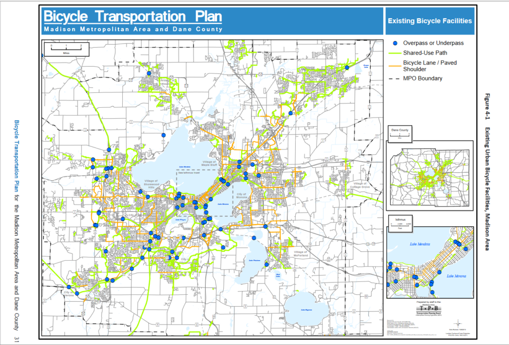
Bicycle Transportation Plan, Madison Area Transportation Planning Board (Wisconsin)

The Madison Area’s Bicycle Transportation Plan underscores the pivotal role of shared-use paths within Dane County’s expansive regional bicycle network. Recognizing their significance, Dane County boasts an impressive network spanning over 500 miles of these paths. These pathways have emerged as popular conduits for diverse trip purposes, encompassing daily commutes, general errands and leisurely recreational rides. Their widespread usage underscores their value in promoting active transportation, enhancing connectivity, and catering to the multifaceted needs of residents and visitors in the county.
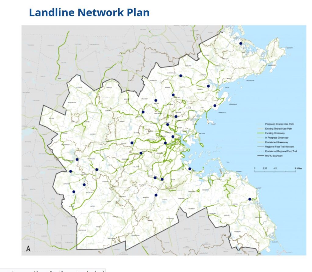
2040 Long-Range Transportation Plan, Boston Region Metropolitan Planning Organization (Massachusetts)

In 2015, the Boston Region Metropolitan Planning Organization released its 2040 Long-Range Transportation Plan, which includes a section on off-road bicycle or multiuse paths as part of its conversation on the expansion of bicycle and pedestrian networks. This section of the plan emphasized the agency’s prioritization of connections between regional trail systems and multiuse trails. Shortly thereafter, the “LandLine”—the vision for a 1,400-mile connected network of trails and greenways within the Boston region—was born. This led to a follow-up document: the LandLine Vision Plan, with an overarching objective to complete the 1,400-mile trail network and spur new opportunities for active transportation and recreation across communities.
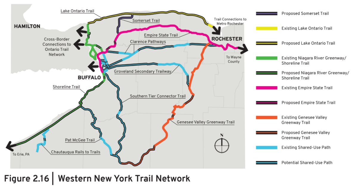
Moving Forward 2050: A Regional Transportation Plan for Buffalo Niagara, Greater Buffalo Niagara Regional Transportation Council (New York)

Moving Forward 2050 emphasizes prioritizing multiuse trails, especially along shorelines, to boost public access. It advocates for extending these trails into rural areas for equitable accessibility. The plan proposes to measure progress by expanding dedicated bike paths, shared lanes and multiuse trails within communities. Additionally, Geographic Information System (GIS) maps are utilized to clearly label and visualize these trails, aiding in informed decision-making and planning.
Regional Transportation Plan, Tuolumne County Transportation Council (California)
The Regional Transportation Plan presents a comprehensive overview of existing and future trail infrastructure within the County of Tuolumne, including both soft-surface and hard-surface trails. A significant milestone that’s highlighted is the commitment made by the Tuolumne County Transportation Council in 2011 to dedicate 25% of its planning staff’s hours to enhancing and expanding the county’s nonmotorized transportation system. This approach enabled the staff to identify strategic measures aimed at facilitating, prioritizing, funding and constructing trail links throughout the county. The primary objective was to seamlessly connect residents from their neighborhoods to prominent commercial centers, marking a pivotal initiative within the trails program. Overall, the document underscores the importance of promoting connectivity and accessibility throughout the county, and recognizes trails as invaluable assets in helping to achieve these goals.
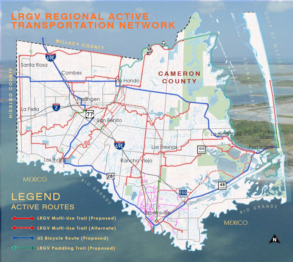
Lower Rio Grande Valley Active Plan (Texas)

The Lower Rio Grande Valley Active Plan is both a transportation plan and an economic plan. The plan seeks to provide a framework for the development of a high-quality nonmotorized network across Cameron County, Texas, offering transportation choice and improving health outcomes and quality of life for residents. In addition, this network is central to the region’s tourism strategy, attracting visitors to enjoy the region’s natural, cultural and historical attractions, thereby boosting the local economy. The plan, developed in collaboration with the University of Texas School of Public Health (UTHealth), the Valley Baptist Legacy Foundation, and city and municipal partners outlines the vision for the Caracara Trails network, which spans 428 miles and includes 230 miles of multiuse trails, 120 miles of U.S. Bicycle Routes and 78 miles of paddling trails.
Resources
‣ Plan – Oregon Non-Motorized Trails Plan
‣ Plan – Wisconsin Trails Network Plan
TrailNation Collaborative
TrailNation™ Collaborative is a nationwide peer learning community from Rails to Trails Conservancy that brings together advocates, leaders and professionals from across disciplines to establish and accelerate trail networks across America. The collaborative provides proven tools, methods and resources, combined with RTC’s expertise and network of partners across the country, to accelerate the development of connected trail systems. When trails are connected across regions and states, trail networks have a proven transformative impact—they are essential infrastructure that creates thriving, healthier communities.