Focus Term: Design
Blog
Court Sides with Advocates for Derry Rail Trail Tunnel in Lawsuit Over Historic Rail Corridor
June 30, 2025
The Committee to Save the Derry Rail Trail Tunnel and RTC celebrated a victory in their lawsuit against the New Hampshire DOT and the FHWA.
resource
Webinar – Trail-Oriented Development: How Trails Create Connected Communities
May 08, 2025
Trail-Oriented Development (TrOD) is an innovative planning approach that integrates multiuse trails with residential and commercial development to create walkable, bike-friendly communities that enhance mobility, promote healthier lifestyles, and strengthen local economies. Similar to Transit-Oriented Development (TOD), TrOD clusters businesses, housing, and other amenities around trails to foster vibrant, connected neighborhoods. Join the TrailNation Collaborative, […]
resource
Mid-South Regional Resilience Master Plan
April 12, 2025
Resilience is vitally important to every single person living in the Mid-South. Climate and weather-related shocks and stressors have major impacts on safety and quality of life for all residents, regardless of age, income, race, community, etc. Mitigating these threats and building the capacity to bounce back quickly from disasters will keep residents safe and […]
resource
Trails as Resilient Infrastructure
April 12, 2025
This guidebook demonstrates how trails are part of resilient transportation infrastructure, how trails can be planned and designed to be resilient and sustainable, and how trails have a role in emergency planning and response. Trails of all kinds are places for recreation, exercise, and active transportation. Trails are also a crucial tool for making communities […]
resource
STEP: Improving Visibility at Trail Crossings
June 13, 2024
The focus of this resource is on improving the driver’s visibility of trail users at roadway crossings. The document presents a systemic approach to reviewing existing crossings or planning for improved at-grade trail crossings with engineering countermeasures, such as enhanced signs and traffic controls. This resource discusses ways to make crossings more visible to drivers. […]
resource
Best Practices Synthesis and Guidance in At-Grade Trail-Crossing Treatments
September 01, 2023
At-grade trail crossings have frequently been the sites of bicycle, pedestrian, and snowmobile crashes in Minnesota and throughout the nation. To date, many resources exist for use in the design of trails and intersections, such as the MnDOT Bikeway Facility Design Manual, while guidelines of traffic control at roadway-trail crossings are covered in the MN […]
resource
Accessibility Toolkit for Land Managers
October 01, 2020
The Accessibility Toolkit for Land Managers is an informative document meant to help land managers design and maintain with equity and inclusion as a priority. The toolkit dives into what equity and access look like, who we’re talking about with examples of demographics, commonly used equipment, and desired recreation. We discuss shifting the lens and […]
resource
Montgomery County Trail Access, Diversity and Awareness Plan
August 01, 2020
The Montgomery County Trail Access, Diversity and Awareness Plan provides detailed descriptions of the Schuylkill River Trail in Norristown and Pottstown, as well as the portion of the Pennypack Trail located in Montgomery County, PA. Analyzing how a trail looks and functions is the first step to determining which factors may prevent people from using a trail. This […]
resource
MnDOT Bikeway Facility Design Manual
February 01, 2020
The purpose of the Minnesota Bikeway Facility Design Manual is to provide engineers, planners, and designers with a primary source to implement the Minnesota Department of Transportation (MnDOT’s) vision and mission for bicycle transportation in Minnesota. This manual also provides citizens, developers, and others involved in the transportation planning process, guidance on the critical design […]
Blog
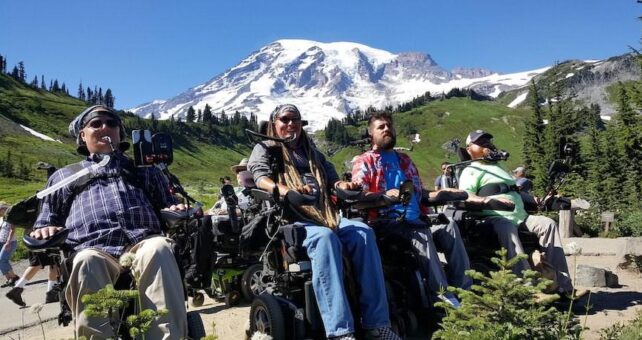
A Serious Injury Changed Cyclist Ian Mackay’s Life. Trails Helped Him Rebuild It.
August 27, 2019
A motorized wheelchair powered by sip-and-puff inputs coupled with the ever-improving voice recognition capabilities of a smartphone offered Mackay a degree of independence, and allowed him to get outside without a caregiver at his side at all times.